|
|
|
Why is the Square in the Shaker Heights
School District?
|
 |
Historian Virginia Dawson, Ph.D.
answers
this question the way
historians do - by extensive research and by relying on source
documents. We know of no better explanation and thank her for sharing it here. |
|
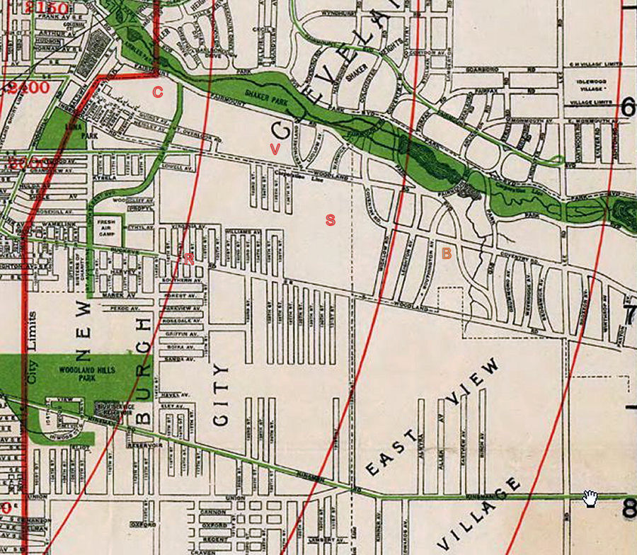
The Van Sweringens had been selling the farmlands that had once belonged to the Shakers since 1905. The Shaker property at that time was part of Cleveland Heights Village and straddled Shaker Lakes Park. At the same time William Van Aken was subdividing his mother’s farm and other properties in what is now the Larchmere area of Cleveland. In contrast to the large lots and palatial homes planned by the Vans along South Park Boulevard and Lee Road, the lots west of East 130th Street that Van Aken was selling were intended for small, two-family houses. Van Aken had succeeded in getting the Village of Cleveland Heights to allow him to cut a new street (East 128th Street) from North Woodland Road (Larchmere Boulevard) to the edge of the old Shaker quarry, now the location of the Cleveland Skating Club. The Cleveland Heights Council’s refusal to finance the building of sidewalk prompted him to run for a seat on the council. During this time Van Aken renewed his friendship with the Van Sweringens, which dated back to the days when as schoolboys the three Vans had delivered copies of the Cleveland Leader to farms on the Heights. Though defeated the first time he ran, with the Van Sweringens’ backing, Van Aken won a seat on the Cleveland Heights Council in the next election. “We got out the vote, and became fast friends again,” the mayor of Shaker Heights told a reporter years later. Municipal control of the former Shaker lands south of the park was the Van Sweringens’ objective and with Van Aken as an ally, they moved forward with a bold and complicated plan to detach Shaker Heights from Cleveland Heights. In July 1911, the County granted a petition to incorporate Shaker Township, the first step in the founding of Shaker Heights. In addition to the former Shaker farmlands on the south side of the park that the Vans were developing, the township included a narrow strip of land west of the Shaker farmlands down to the Cleveland boundary, terminating a little east of the Baldwin Reservoir. Almost immediately, residents living in the westernmost section of the new township below Rice Boulevard, petitioned to have their section detached and annexed by the City of Cleveland. This annexation took place in September 1912. It is likely that Van Aken anticipated that the subdivision he was developing would also be annexed by the City of Cleveland. If the children in his subdivision could also attend nearby Rice School at East 116th Street and Buckeye, it would make the lots there easier to sell. This was presumably the rationale for the 1912 School District Agreement between the Shaker Heights and Cleveland Boards of Education. The two school boards exchanged, or swapped, territory in their respective jurisdictions. Cleveland’s Board agreed to educate the children west of East 130th at Rice School, which was closer than the yet-to-be built Boulevard School in Shaker Heights. In exchange, Shaker Heights took responsibility for educating the children in a part of Newburg City, located south of North Woodland Road (Larchmere Boulevard), which was closer to Boulevard School. This area later became known as Shaker Square. The valuation for tax purposes of the two territories exchanged was equal. The final step in what appears to have been a carefully choreographed series of steps took place in 1915 when the City of Cleveland annexed the remaining part of Shaker Township (Van Aken’s section) in 1915. The west lot lines of East 128th Street became the boundary separating Shaker Heights from Cleveland, not East 130th Street. The reason for this anomalous boundary was that Van Aken, then serving on the Village Council, lived on East 128th Street. Naturally, he needed to reside within the boundaries of the village. To show his appreciation for the Van Sweringens’ willingness to accommodate him a second time, Van Aken invited the volunteer fire department to keep a shed for the village fire truck on his land. Elected mayor in 1915, he served for almost 36 years. The genial leader never wavered in his loyalty to the Vans, assuring a tight relationship between the municipal government and the Van Sweringen Company throughout his tenure. At the time of the School District Agreement, much of what became the Shaker Square area was still open fields. Although the Van Sweringens died in the 1930s, Mayor Van Aken would live to see the development of Shaker Square and must have gloried in the enormous contribution to the property taxes of the Shaker Heights schools the commercial development of the Square entailed. Children living in the Shaker Square area attended either Boulevard or Ludlow Elementary School in Shaker Heights, depending on whether they lived north or south of the Square. Cleveland politicians often found it convenient to live in Shaker Square so their children could benefit from the excellence of Shaker Schools. The 1912 agreement also shaped the way Shaker Heights became integrated in the late 1950s and 1960s. Upper middle class African-American families purchased or built attractive homes in the Ludlow School District so that their children could go to school in Shaker Heights. As they moved across the line, the suburb gradually became integrated, thanks to grassroots and official support by the city. ● |
|
Notes by Arnold Berger
|
|
|
|
For more on the
history of Shaker Square, |